Croxteth is much more than Croxteth Hall. The hall and its 500-acre country park are the best-known landmarks, but most local life happens across residential estates, schools, shopping parades, community facilities and bus routes between the East Lancashire Road, Muirhead Avenue and neighbouring West Derby and Norris Green.
The distinction is important because online guides often merge three different things: the older Croxteth estate around the hall, the modern residential neighbourhood of Croxteth and Croxteth Park, the large housing development east of the country park. Liverpool’s present ward map reflects some of that complexity with separate Croxteth and Croxteth Country Park wards.
There is no perfectly agreed line around the neighbourhood. For practical purposes, Croxteth sits in north-east Liverpool, with Gillmoss and the East Lancashire Road to the north, Norris Green to the west, West Derby to the south and the Knowsley boundary towards the east.
How the modern neighbourhood developed
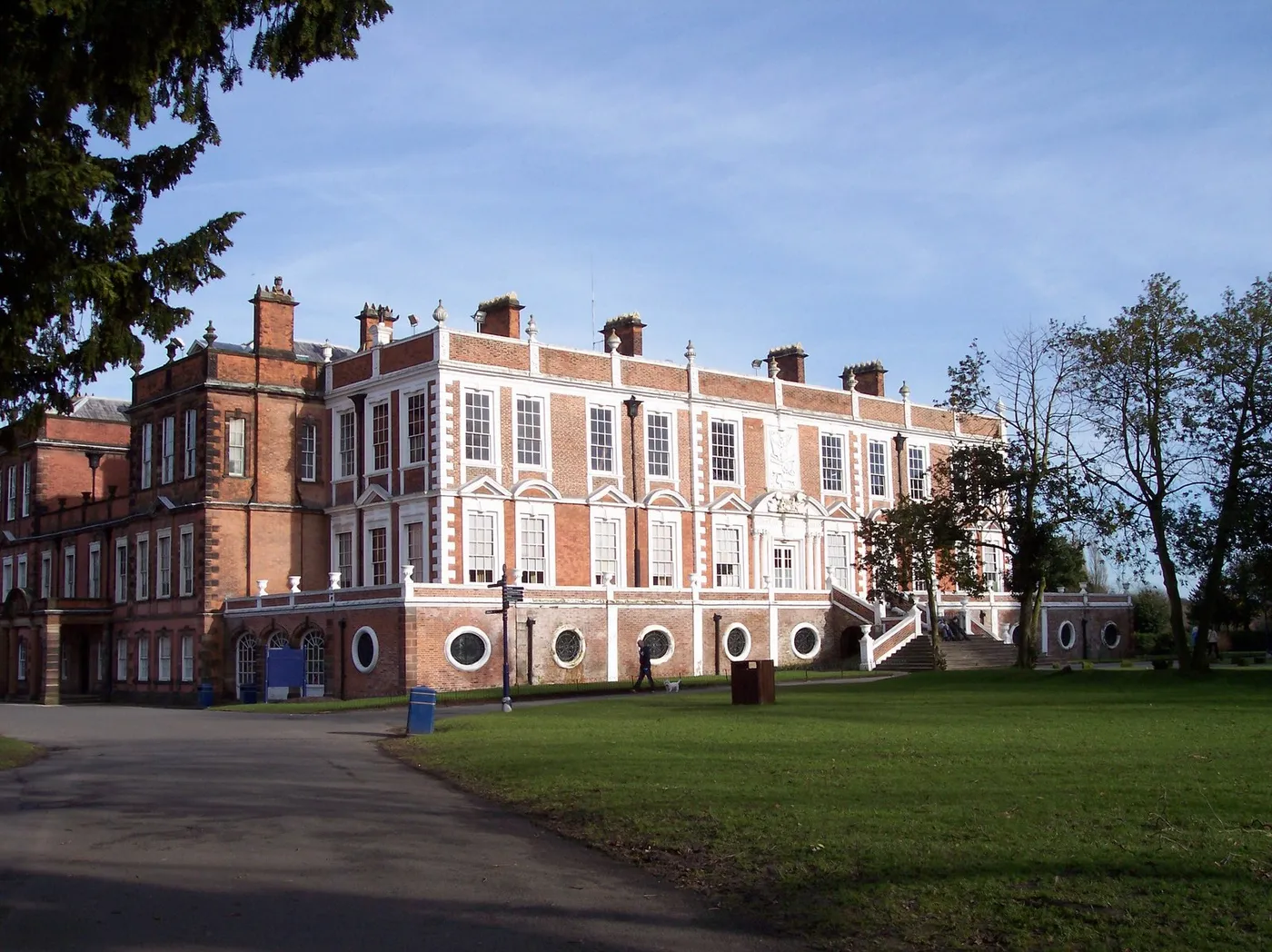
Croxteth Hall was the home of the Molyneux family, later the Earls of Sefton. Historic England records that the park was granted to William Molyneux in 1507 and became the family’s main residence. The surviving hall was built and extended over several centuries and is now Grade II* listed.
That history belongs to the area, but it is not the history of most of its housing. Much of modern Croxteth grew through twentieth-century council building as Liverpool expanded beyond its older inner districts. Later private development created Croxteth Park, where newer estates sit close to the historic parkland and West Derby.
The result is an area with very different housing environments under one name. Streets around Stonedale and the East Lancashire Road have a different layout and history from Croxteth Park estates near the country park. Discussions about services, transport or house prices need to say which part they mean.
Shops and everyday services
Croxteth does not have one traditional high street. Shops and services are spread between local parades, supermarkets and nearby district centres. Broadway, around Broad Lane, is important for residents across Croxteth, Norris Green and Clubmoor even though it is not wholly inside Croxteth itself. West Derby Village and retail sites along the East Lancashire Road also serve parts of the area.
This dispersed layout makes local convenience stores, takeaways, pharmacies, schools and community centres particularly important. Losing one service can have a bigger effect where the alternative is another bus journey rather than a five-minute walk down a high street.
Croxteth Children’s Centre provides early-years and family support. The Rhys Jones Community Centre on Langley Close is another local base for activities and community use. Liverpool City Council groups Croxteth with the wider Broadway neighbourhood for its neighbourhood-service model, alongside Clubmoor, Norris Green and West Derby Muirhead.
Croxteth Hall and Country Park
The park is not the whole neighbourhood, but it is an exceptional local asset. Liverpool City Council describes Croxteth Country Park as 500 acres of woodland, pasture, ponds, streams and paths. It gives nearby residents access to a scale of public green space that most parts of the city do not have.
The country park is free to enter, while the hall, farm, miniature railway and individual events follow different opening times and prices. Anyone planning a dedicated visit should read L1Local’s separate guide to Croxteth Hall and Country Park, which checks the current arrangements for each attraction.
For residents, the park is also an ordinary walking, running and dog-walking space. Croxteth Hall parkrun takes place on Saturday mornings, and the council publishes a five-kilometre route through the estate.
Getting around Croxteth
Croxteth is heavily dependent on buses and cars because it has no railway station. The 18 currently operates as a Liverpool ONE to Croxteth Park circular and serves Muirhead Avenue. Other services cover the East Lancashire Road, Willow Way and connections towards nearby districts.
Bus numbers alone do not explain access. Croxteth covers a wide area, and a route convenient for Muirhead Avenue may leave a substantial walk to another estate. Check the exact stop with Merseytravel before travelling, particularly in the evening or on Sundays.
Main roads include the A580 East Lancashire Road, Muirhead Avenue, Croxteth Hall Lane and Stonebridge Lane. These provide useful connections but also divide parts of the neighbourhood and make some short-looking trips less comfortable on foot.
There are more than ten pedestrian and cycle entrances to the country park, so local access is not limited to the main Muirhead Avenue vehicle entrance. Routes within the park vary from surfaced paths to muddy woodland trails.
Housing and the Stonedale redevelopment
Housing condition and redevelopment remain important in Croxteth. Stonedale, off the East Lancashire Road, is undergoing large-scale estate regeneration led by Cobalt Housing. In April 2025, the Liverpool City Region Combined Authority reported that an additional £300,000 of Brownfield Land Fund support was proposed to help the project begin.
Brownfield funding is public money used to prepare previously developed land for new building. It does not by itself confirm every detail of the final scheme. Residents should distinguish between funding allocations, approved planning applications and homes that have actually been built.
The practical questions are how many homes will be replaced, which tenures will be provided, how existing residents are rehoused and whether new streets come with usable green space, transport and community facilities. Those details matter more than a headline number.
Local issues that matter
Transport is one of Croxteth’s clearest pressures. A missed or withdrawn bus has more impact in a neighbourhood without rail access and with services spread across several centres.
The future of Croxteth Hall is another long-running question. The building and park require maintenance and public funding, while event income and commercial uses can help meet costs. The test should be whether changes protect public access and the historic estate rather than turning a community asset into somewhere local people can only use occasionally.
Housing redevelopment, youth services, park maintenance and access to health services also deserve continuing coverage. Croxteth is often mentioned in city reporting only when something goes badly wrong or when a large event arrives at the hall. A proper area page should make the ordinary infrastructure visible too.
Nearby areas
Croxteth connects directly with Norris Green, Gillmoss and West Derby, all part of north and east Liverpool. Croxteth Park runs towards the Knowsley boundary and is often associated with West Derby because of its L12 postcode and nearby services. These places are connected, but they are not interchangeable.